Rocky Mountain National Park I: Emerald Lake
We had one week to see as much of Colorado as we could. But it only took us maybe an hour after landing to start asking, “Why did it take us this long to get out here?”
We boarded a nonstop flight in from RDU and spent the first night in Denver itself. Realistically, there is no reason one couldn’t fly in early and go directly to Rocky Mountain National Park and right into camp for the first night; but we weren’t sure about logistics this being our first trip. Hence the reason you must explore.
But this did give us time to collect any additional needed items for the expedition. We stopped by REI’s flagship store in the Denver area, located in a big brick building that was once a power station, to get gas for the Jetboil and other items we could not (or forgot to) take with us. Sylvia pronounced this the biggest and best REI she had ever seen, surpassing the stores in San Francisco, Asheville and even Seattle.
A word about forgotten items – this trip would see a lot of those. This was, in fact, possibly the poorest planned and executed trip that Minister of Expedition Planning Brian has ever staged, and that’s saying a great deal. The ensuing posts will contain more than a few mentions of this. Brian chalked it partially up to simply not having enough time to prepare, or maybe just advancing age. Or both.
Or maybe it was something else. Our nephew Mikey, an armchair expert of sorts on the paranormal, had warned us about a demonic, cursed horse who guards the entrance of Denver International Airport. This horse, named Blucifer, suffers none to pass him without paying due homage. We scoffed at Mikey and accused him of smoking a substance that would be legal in Denver.
However, as we drove out of the airport, who should appear but…Blucifer. He did not challenge us, but his red eyes followed us. We drove quickly by, uneasy, having failed to pay homage and feeling we had somehow been cursed.
The drive from Denver to Estes Park was scenic and easy, with traffic encountered only in the small hamlet of Lyon where some sort of festival was going on. The last twenty miles to the park, through canyons that reminded us of Oak Creek Canyon outside Sedona, was especially nice. Brian had heard very bad things about the over development of Estes Park, which to some people is the very epitome of a gateway city gone haywire. Actually, he was pleasantly surprised to find that, at least when we were there in late August, it was not too bad. Not like certain other places we know of. More on that later.
As we rolled into Estes Park we got out first look at the stunning Front Range peaks that bisect the park. Chief among them, and unmistakable even at a distance, is Long’s Peak.
We had decided to stage out of Moraine Park Campground, the largest in the Park. Like all the developed campgrounds on the eastern side of RMNP, Moraine is booked up months in advance, so arriving on sight and expecting a spot is pretty much an exercise in futility. We had been told that some weeks the entire campground will be booked up five months ahead of time. We had actually been lucky enough to find our spot just a few weeks before, but it took some looking.

Again, Brian had been expecting a complete mob scene, but was pleasantly surprised to find this was not the case. His experiences with Great Smoky Mountain NP, and the three ting circus that surrounds it, might have prejudiced him.Though certainly busy, Moraine campground is large and well spread out enough so that each spot has plenty of space, with a few exceptions. (Two of those exceptions were the sites immediately between us and the road, which had a birds-eye view and smell of an overflowing dumpster.)

Even before reaching the campsite, Brian had discovered his first bit of folly (or the first evidence of the curse.) He’d forgotten to pack his rain gear, a necessity in the Rockies where afternoon thunderstorms are clockwork. Fortunately, he was able to rectify this with a stop in REI.

But at the campground he discovered his second, and more serious, mistake. He had forgotten BOTH our Thermarest sleeping pads. We would be forced to sleep directly on the pebbly soil beneath the tent. A bummer.
Had Brian’s failing memory finally failed completely– or had we fallen victim to Blucifer’s curse?
At any rate, the campsite was a nice one, situated a bit up on a hill…Long’s Peak appeared to be looking straight down at us.
With plenty of daylight left, our destination that day would be a moderate hike considered one of the most scenic in the park, Emerald Lake. This short hike would be a good opportunity to acclimate ourselves to the altitude (the campsite itself was over 8000 feet; virtually any serious hike in this park goes over ten thousand.)
Emerald Lake
The Trailhead to Emerald Lake is located at the end of Bear Lake Road, not far from Moraine Campground. Because this area has a number of very short and scenic hikes, it is heavily visited by tourists, hikers and would be hikers alike. The result is that there is seldom enough parking at any of the trailheads to accommodate the huge crowds.

The NPS handles this by asking visitors to park at a central lot and shuttling them out to the trailheads in buses that run every few minutes. While not exactly the pinnacle of comfort, we found this system did in fact work to manage the crowds. It reminded us of the crowded shuttle buses of Alpine France and Italy, full of sweaty hikers and backpacks; for a while we thought we were back on the Tour du Mont Blanc.
We caught the shuttle directly from the campground. As we boarded, a bunch of kids got off, carrying at least 400 pounds of gear which they had lugged all the way from Florida via the airport (they had no car.) They had suitcases, packs, big rubber totes, even a guitar. And we thought we were ambitious.
After some confusion we finally made it to the trailhead at the terminus of Bear Lake Road. It’s a busy place, with people milling all over the place. Some of these come intent to hike, but others just seem content to stand around and mill.

The Trail to Emerald Lake diverges from the shorter trail to Alberta Falls (Only a mile distant; if you have time you can easily do both) and heads uphill gently first on a walkway, which becomes the remains of what appears to have once been a longer walkway, and finally on a straight-up dirt trail. It’s about a mile and half to the lake…passing two other lakes en route. The first of these, Nymph Lake, is actually sort of an unattractive bog covered in lily pads this time of year. But that does not stop people from posing at the shore to take an endless procession of selfies.


This is a heavily used trail. It is wide enough in most places for people to pass in both directions. Brian’s strict adherence to the protocols of hiking caused him to defer to oncoming hikers for a while and let them pass; but after a mile or so of this most just give up, as we did, and keep hiking while two-lane traffic goes on by. You just get tired of stopping to wait while groups of five to ten people at a pass you, often with surly looks on their faces. Must be the elevation.

As the trail climbed, we began to feel the elevation. We had no idea how high up we were; Brian suspected the trail head to be at perhaps 6000 feet. In fact, it was over eight thousand.
After Nymph Lake comes some ledgy areas with great views. Some of these views were being hogged by the typical pack of selfie takers, but just a bit uphill there were plenty more open ones. Some people just don’t want to climb more than they have to.


On the way up, Sylvia paused at least three times to point out how great her new pair of Keene hiking sandals were. This would be pointed out again on this trip not less than 30,000 times.

At about 1.3 mile comes Dream Lake. This is a much nicer lake than Nymph; here, a few people were actually in the water fly fishing. The trail meanders along the right shore, and we could spot a number of trout (cutthroats by the look of them) just a yard or so from the trail in the shallows.


The trail follows the stream that feeds all three of the lakes; there are some nice little cascades.


Just below the outflow from Emerald Lake there is a boggy meadow. We’d already heard reports from passing hikers that there was a different sort of crowd here, and when we turned the bend confirmed this was the case. Man, these guys were just really blocking the trail. No sense of decorum.


This was the first time Brian and Sylvia have ever detoured from the trail to avoid large wildlife, domestic livestock excluded. In this case, we ended up cutting uphill on game trails made by the elk…in other words, because the elk were infesting the human trails, we were forced to use theirs.
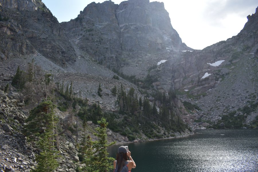
At any rate, we soon reached Emerald Lake. It was spectacular, though we arrived at the wrong time of day for the photos to do it any justice. There is a nice viewpoint, though you have to climb over a boulder to two to reach it.


As we admired the beauty of the lake, Sylvia turned to me and said, “I just love my new sandals!” Always in the moment is Sylvia.

The glacial cirque the lake sits in reminded Brian of the cirque occupied by Grinnell Glacier in Glacier National Park, which he visited over a decade ago.
You can also make your way down to the lake shore and wander around to get further from the crowds. But the better views are from the rocks. As we sat and watched, trying the steer clear of begging chipmunks and gray jays, some enterprising soul did in fact jump right in for a swim. He got out in a hurry. That water is glacially fed.

After taking in the sights for a while we realized it was getting late, and the last shuttle bus left at 7:30 pm. And so we turned around and went down , down, down, passing crowds still huffing and puffing there way up. We reached bus station and hopped on the first bus, getting a seat this time…all told the hike took us maybe two hours, We were back in camp by about seven pm. As we walked back to our site, we passed a small herd of mule deer.


The campground was equipped with a bear box – they are quite serious about bears here. We got out our food and made dinner. Then…into the tent for a pebbly night of tossing and turning.
Tomorrow, Blucifer willing, we’d try out hand at a more ambitious hike.
