The Hike
- Torres del Paine NP, Chile
- Distance: About 45 miles if all sections done to their fullest extent
- Elevation Gain: AllTrails lists it as 8956 ft but this will again depend on itinerary
- Time: Five days recommended; possible in four
- Difficulty: Moderately Strenuous
- Best season: November to April (spring thru fall in the Southern Hemisphere)
- B.I.T. Rating ****1/2
Directions: Travel here is complex. Torres del Paine is best reached out of Puerto Natales, which is itself best reached out of Punta Arenas, which is typically reached from Santiago, Chile. There is a small airport just outside Puerto Natales but flights into it are sometimes hard to book.
Brief Description: This most popular of Patagonian Treks is not so much one continuous walk as it is three out and back hikes (the ‘fingers’ of the W) strung together by a connecting trail that forms the base of the W. Many itineraries are possible here; the main problem, apart from weather, is the logistical complexity of advanced bookings that MUST be made in order to accomplish this very popular hike. Don’t underestimate its difficulty.
Trail Map (from AllTrails)
Why Do This Hike?
- Recommended for strong, self sufficient hikers
- One of the most popular and sought after hikes in the world
- See the best of famed Torres del Paine National Park
- Avoids the hardest sections of the full circuit (The “O”) while bagging most of its scenic highlights
- About as far south as a person can get and not be in Antarctica
- Weird, otherworldly Patagonian landscapes
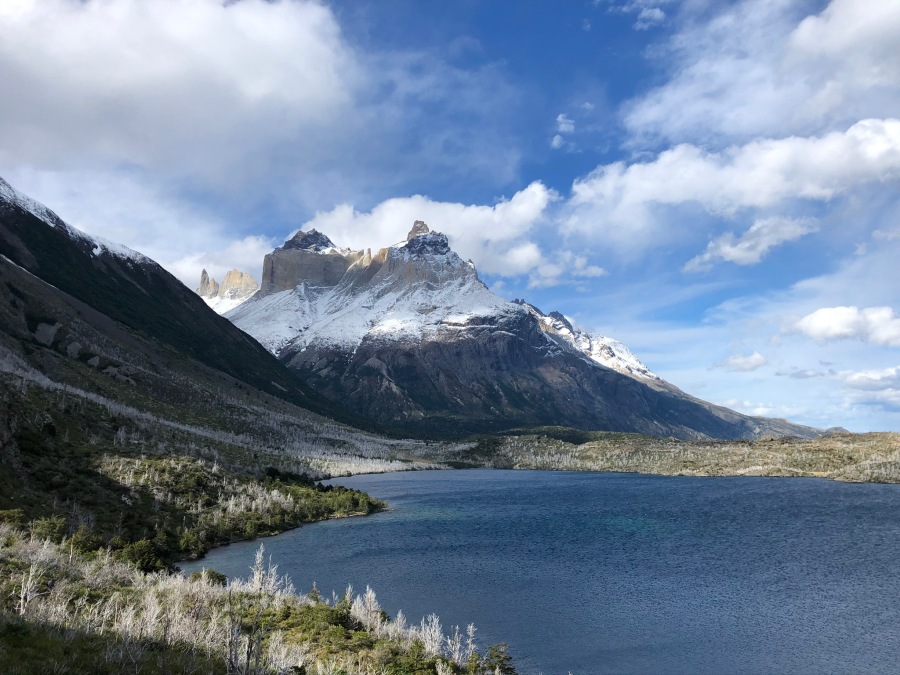
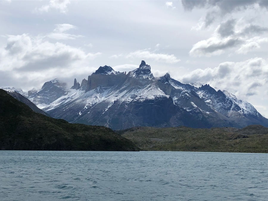
- Fantastic oddly shaped and colored peaks
- Lakes that seem to change color with the shifting light
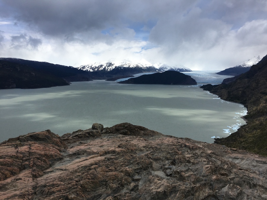
- HUGE glaciers
- Highlights are almost household names in the trekking world
- The Towers, The Horns and Glacier Grey
- Altitude not a factor
- Well marked trails, little chance of getting lost
- Some steep up and down but no prolonged ascents
- Hike sticks mainly to the lower slopes
- Most stream crossings on the W are bridged or fairly easy (high water excepted)
- Unique flora and fauna
- Giant flightless birds, flamingos, condors
- Rare Huemel deer
- Chance of seeing a puma
- Impressive fall color show
- In spring, almost continual avalanches can be observed from a safe distance
- Meals, supplies can be purchased throughout the hike
- The best and most authentic way to see this is tenting the whole way
- It’s possible to rent gear along the way and lighten the load while still camping
- Option to stay at refugios can reduce the pack to day hike weight
- Consider the the much longer and more challenging full circuit (the “O”)
- Trips begins (or ends) with very scenic catamaran ride on Lago Pehoe
- Combine this with sightseeing trip out of Puerto Natales to Berndardo O’Higgins NP (Whales, penguins, sprawling glaciers etc)
But First Consider:
- Biggest issue here is the weather
- Wind, rain, sleet…and that can be a GOOD day 🙂
- Region is known for strong winds
- Tents, pack covers, maps and important papers, even hikers get blown away
- Even in summer, low cloud cover often obscures the peaks
- Understand this: You could hike here for days and see nothing but clouds
- In addition to the weather, the trails are rough and primitive
- Do not be fooled by trip reports/marketing materials that describe these trails as easy or moderate, this is a tough hike
- There are many moderate sections, but many difficult ones as well
- A lot of up and down, some of it steep
- All the ‘fingers’ of the W have difficult stretches
- Many sections MUST be backtracked, and some of these are the most difficult ones
- Areas around Lago Grey are especially windy
- Muddy, boggy and rocky sections…many times the trail itself is a running stream
- We noted (in direct contrast to Los Glaciares NP) little sign of any trail maintenance
- Very tiring with a heavy pack
- Strongly consider all options to reduce pack weight and increase enjoyment
- We were unimpressed with the refugios. While modern and offering a wide range of services, they manage to retain the noise and crowds of European hostels without the charm
- Some of the camping areas were private and protected from the wind; others were more like football fields filled end to end with tents
- The CONAF run Italian Camp was squalid
- Logistics on this popular trek are complex and seem to get worse every year
- Advanced bookings required; hikes now have cut off times
- Expect lengthy delays and monkeyshines at the Amargo Sur entrance station
- Unless you are a very strong hiker, do not except to begin hiking the day of arrival at the park
- The full traverse can now be done only in one direction (it is still possible to do the W in either direction)
- Book campgrounds, rental gear and meals months in advance
- If you want a bed in a refugio or bungalow, try YEARS in advance. 🙁
- A key cog in the W is the catamaran between Pudeto and Paine Grande, which runs infrequently and cannot be booked in advance
- By all accounts the backside of the O is MUCH rougher than the W
- The Pass of John Gardner is by far most difficult (and dangerous) section of the full circuit and surpasses anything on the W
- If your plan is to just show up here and start hiking, think again…those days are largely over