Big House Mountain, VA
*We have added the Big House Mountain hike in House Mountain Preserve to our list of the Best Hikes in the Southern Appalachians. It is a REALLY interesting hike in west-central Virginia. Note that there are several options to this hike and the one we ended up hiking was…somewhat on the creative side. There are easier options along this route than the off-road adventure we chose.
After a night at the Peaks of Otter we drove down to Lexington, VA to find the House Mountain trail and get going on our adventure. Alas, the drive took over an hour, so we did not get the early start we wanted to beat the crowds and heat.
Fortunately there were neither crowds nor heat to beat. We were only the second car at the parking lot. A third pulled up as we were there, but we hardly saw that group all day. And while warm, it never got oppressive in the high country.
Most trail descriptions make clear that parking at this trailhead is scant, and this is no joke. We estimate MAYBE six cars could fit comfortably along this stretch of steep dirt road. But there seem to be more places to park further down the road if you don’t mind more walking. At any rate, this is a public (though little used) road lined with private homes, so respect the property owners and don’t block the driveways. End disclaimer.
Our plan was to hike one of those summits, at least. Both, if we could. We knew it to be a serious undertaking. House Mountain is an unusual ‘Y’ trail with a pair of branches going left and right from a fork. Both lead to summits with views. This means if you want to do BOTH summits, you have to pass through the fork three times. It also means that while there is less than six miles of actual trail, the entire hike (if both branches are done) is more than nine miles long, total.

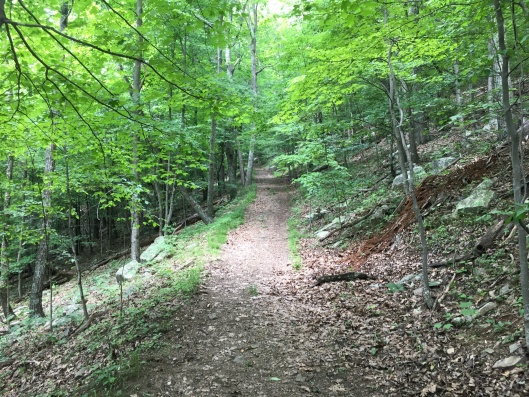
The first part of the hike follows a pleasantly winding gravel road, which passes through a gate, steepens and becomes the Saddle Trail, which is more of a rutted 4×4 road. This section is relatively straightforward, moderately steep and moderately boring. Road walking is just never fun. The trail ends, not shockingly, at a grassy saddle, where there is a junction and a nice campsite. The Big House Mountain Trail diverges left, while the Little House Mountain Trail goes right.
Two interesting things about this saddle. One was that I nearly walked into a surprisingly un-alert deer in the high grass, which did not see me until the last moment, then abruptly looked at me, did a double take and bolted. It was not the first deer we saw nor the last by far. It wouldn’t even be the only one we spooked.
The second thing of interest was that just below the summit we chanced to hear the approach of a motor and, what should come trundling along the 4×4 road but…a four-wheeler with a trailer behind and two men aboard. These turned about to be a pair of the trail maintainers coming back from a morning’s work. We chatted a bit before parting.
A short time later Sylvia chastised this guy for allowing her to step in mud. Mud on a hiking trail, of all things. Who would have thought?
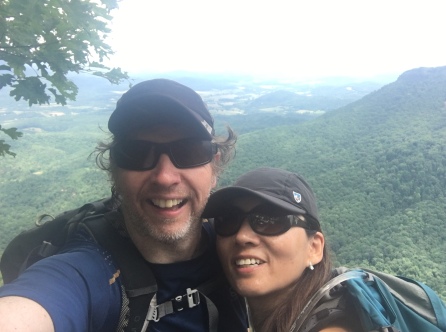
At the junction we had a brief debate, then decided to go for the Big House summit, with Sylvia lobbying heavily for it…Saying it had better views in pictures she had seen online. I had no argument against this. To the Big House it was!
After a few hundred yards on the BHMT there is a shelter, the BHMS. It is a standard AT type kiosk shelter of the old style, not large…there is no adjacent privy that I could see. Apparently there is a creek near here where water can be found in at least some seasons. Be advised that in June, we saw NO water on this trail at all, and no sign of it apart from the infamous mud. I didn’t check to see if the creek was flowing.
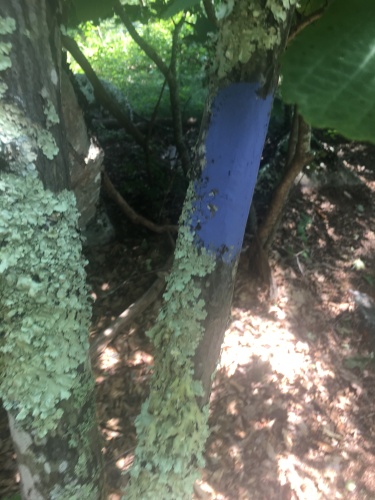
Not far after the shelter the trail turns abruptly uphill and becomes quite steep, though still maintaining the character of an old wooded road. There are no real views along this section though it is pleasant and we saw more deer. This unmarked but obvious road-trail eventually ends at a pair of rock cairns that form a sort of gate, which is also a warning. Above it blue blazes begin, and the trail assumes the character of a standard hiking path.
Not far past the first blaze there is a big ledge, the first of many, and the blazed trail breaks left while the old road appears to veer right up a defile in the rocks and abruptly into disuse. I speculated that this skeletal trace might intersect the route of the BHMT trail further on, and I MIGHT have been proven right. More on that to follow.
Things become quite steep as the blue-blazed trail begins attacking ledges quite directly. In fact, it turns somewhat unexpectedly into a scramble, which comes as a real surprise after all the straightforward walking up to this point.
At the top of the last difficult push is a brushy ridge where we noted an odd thing. The blue blazes go BOTH left and right. We were a bit puzzled by this, but through the trees to the left we could clearly see a camp site, beyond which is a rather obvious view point. After a brief consultation of our map software, we decided that this was ancillary viewpoint which we could visit on the way back if time permitted; the real view, we reasoned, must lie further along the trail. We decided to press on.
(In fact, the spot through the trees to the left IS the main viewpoint on this mountain, termed in some places the Big House Mountain viewpoint, and Goat Rocks in others. We walked completely by it. DUH!) (BUT WAIT, there’s more!!!!)
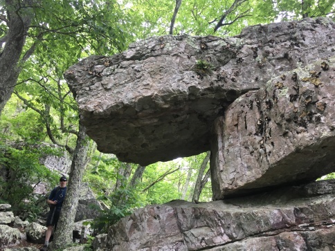
The blue blazed trail is a bit tough to follow once it breaks right, but quickly leads to some remarkable rock formations. There are a couple of impressive lemon-squeezer chasms, a sort of castle-turret style rock cave, and a bizarre T-shaped balanced formation which we later discovered to be named Tabletop Rock.

Past this point, things began to get REALLY interesting.
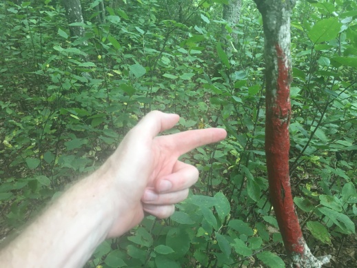
First, the blue blazed trail ends. Abruptly, there are no more blue blazes. But after some puzzled investigation, we found there is a red blazed ‘trail’ of sorts. But it looked…primitive.
Undaunted, as any pair of explorers should be, we decided to press on!
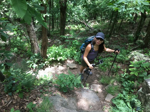
Well. The trail past this point, which we surmise to be new (perhaps the trail crew we saw was working on it that very day?) is more accurately described as a route. The sketchy blazes do not come at regular intervals…sometimes they are close and easy to see, sometimes they are completely enigmas. Some were painted on the stems of bushes or saplings, more than a few at waist level. Sometimes a whole football fields worth of ground chocked with brambles and deadwood lie between them, and sometimes they are just a few feet apart. It is most unusual.
But we weren’t to be deterred. Stepping over logs and branches and rocks, wary of black widows and copperheads, we inched our way forwards, with the persistent call, “Where is the next blaze? Can you see the blaze?” Sylvia proved better at spotting them than I. In the way of old lost paths, the way sometimes was a clear trail and other times simply vanished into the woods.
We realized that we had stumbled face first into a bushwhack.
At one point the nameless red-blazed route does join an overgrown section of grassy road which might be the aforementioned continuation of the old road. This part of the trail reminded me of those ghosts of logging roads in western Maine which I had walked as a boy while on vacation with my parents.
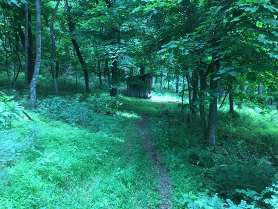
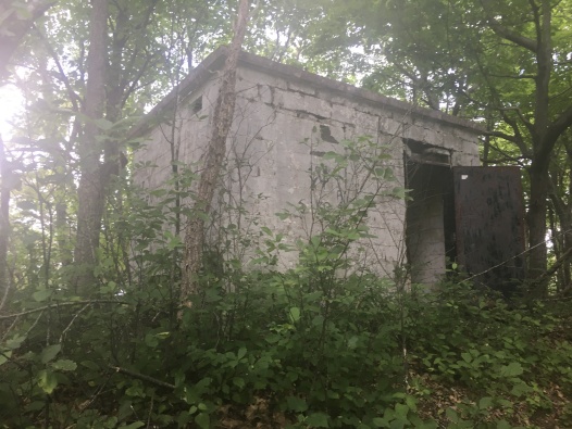
We soon came upon a relic…a spooky structure being reclaimed by the forest. Seems too small to be a dwelling, more of an equipment shed. I don’t know enough about the mountain’s history to speculate on what it’s function might have been back in its obviously bygone heyday.
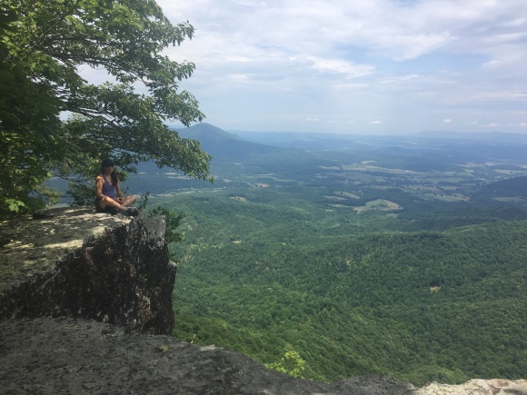
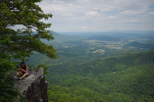
A good half mile of this and we began to descend slightly. After passing along a somewhat rough section (marked with a half dozen BIG blazes for emphasis) we skirted a bluff and began to see clear sky ahead. A ledge appeared, and my excitement level started to rise. Was this the view we’d been stalking all day long? I turned a corner around a bush, stepped out onto bare rock to see…This:

It had been worth it. We had whacked our way to scenic glory!
The view is a unique one. While the first and most popular viewpoint looks out over the farm-studded Appalachian valley and the town of Lexington, this ledge overlooks the narrow, steep walled col between the twin summits. It’s just a fantastic spot. There are many signs of human habitation to either side (I-80 can be see crawling along in the distance) but immediately below is nothing but woods. We were alone but for a few vultures, a pair of circling red tailed hawks, and a single bright scarlet tanager that zipped by. Excepting maybe the trail crew, no one else would sit upon that rock that day but us. We saw no one else going up or down.
Here I took some great pictures of a favorite familiar subject…
Note that the cliffs in this spot are VERY steep and there’s no telling where the bottom is, except that it is lost deep in the trees. Exercise caution and don’t become lost in the trees yourself.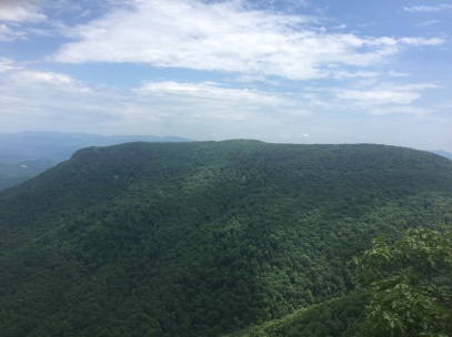
It was a great place to just sit in the shade on the cool rocks and soak in the views. Out on the ledge no human or machine noise intruded at all. Up from the valley came the music of a hundred bird calls at once…A symphony of thrushes, vireos, cardinals, robins and jays, all punctuated by the thin shrill cries of the hawks. I could have spent all afternoon there, but we had to come down sometime, if only to make the four-hour drive back home.
Getting out was less of a struggle than getting in…I had figured out the trick, which was to stay as close to the high point of the ridge as possible and avoid the tangled areas. We did get turned off the trail once by following the grassy overgrown road too far past the cairn where the new trail turns off…I think this road eventually re-joins the main trail further down, but it also might well plunge straight off a cliff. We decided to be prudent and backtracked our way to the blazed trail again.
Descent by the blue blazed Big House trail was laborious…this is a steep trail. No one who has ‘trick’ knees will ever call a steep and rough downhill easy. Tired and focused on the path, we walked right by the true summit without so much as a glance. But then we had spent the better part of an hour with an amazing view before us, and thus had our fill.
Oh. The goat. There’s supposed to be a tame goat living on the mountain since 2011 or thereabouts. I’m not entirely sure what the lifespan of goats is but it seems reasonable that this goat is still alive and perhaps still in residence. If so, he was not active today, we saw no signs of him. We did however see a shadowy, creeping form cross the trail a hundred yards ahead of us on the descent, which neither of us could clearly make out. A bear, a cat, or yet another deer? Maybe the goat? We never got a clear look at it, so we’ll never know.
Once off the blue blazed section, the laborious descent improves a bit but still continues steeply down the gravel-strewn road-trail right back to the saddle. From there the formerly steep-seeming Saddle Trail will seem like child’s play. We were back at the car about six hours after we started. Had we stopped at the true summit, we might have gotten better views or maybe not…but we would have missed a considerable adventure.
What a remarkable day of hiking! Not what we expected and more than we bargained for, but nonetheless the kind of satisfying adventure one can only stumble upon by venturing off the beaten path…even if we did so somewhat by accident. Hey, penicillin was a happy accident, right?
Only in retrospect did realization dawn that we had walked right by the true summit view. Typically, when I research our hikes, I stick to the basic and I don‘t bother going deeply in to detail…which to me would ruin all of the fun of discovery. A couple of my favorite hiking sites, hikingupward.com and virginiatrailguide.com, both cover the hike in extensive detail (including the goat) but make no mention of the red blazed section. At least one site states that there is nothing to see on the mountain past Tabletop Rock, which might have been true when it was written, at least as far as was popularly known. But it’s certainly not true today.
Here’s some of the best of the trip reports…the goat is guest star in some of them.
https://www.hikingupward.com/OVH/HouseMountain/
https://virginiatrailguide.com/2014/07/26/house-mountain-2/
https://www.hikingtheappalachians.com/trail-reports/big-and-little-house-mountain
In fact there is no trail description I can find that mentions the red blazed trail, the summit structure or the second viewpoint we found. I can’t find any details about any of it. Does anyone know what this is?
The land is managed by the Virginia Outdoors Foundation. Nice site…but no info here on the obscure parts of the hike.
Anybody have any more details? If so, drop me a line. I’ll be sure to post an update!
One thing to keep in mind is…if you do the bushwhack section, wear long pants and sturdy shoes. Sylvia was bitten on the leg just above the ankle by what I believe to be a spider. But she seems okay, no serious ill effects or mysterious wall-crawling abilities have appeared yet.
We would not recommend beginners venture beyond Tabletop Rock, but for experienced hikers the walk along the red blazed section should present no serious difficulties as long as care is taken to look for the blazes. We actually found the blue blazed scrambles to be the hardest part. The rewards for going beyond the main track are obvious.
After the hike we stopped in sweltering Lexington, VA, for a burger and beer in the Palms before making the long drive home to NC. We accomplished what we set out to do on House Mountain…our sixth major hike of the year and this one a good one! We’re as ready as we can be for the TMB in July.
What a day! What a weekend! Wish they could all be this good as this escape from the prison that is life can sometimes be…an escape to Big House Mountain!