Tour du Mont Blanc: Can I hike the Tour du Mont Blanc?
Can I complete the Grand Circle of the Tour du Mont Blanc too?
This may be the question you are asking yourself. The celebrated tour of Western Europe’s highest peak is the single most rewarding thing that Brian and Sylvia have ever done. But it is also without question the most physically challenging thing we have ever done – pushing our bodies to the limit to walk serious mountain miles for eleven out of thirteen straight days. And even during our ‘rest’ days, we did miles of more conventional walking.

The Tour du Mont Blanc is a formidable undertaking. It asks much more of you than any of the other hikes featured on these pages. Other multi-day hikes we have done lasted four to five days at most. Some of them included some very hard days (The Santa Cruz Trek certainly did.) But none of them had as MANY hard days as the TMB, with one tough day often being followed by an even tougher one. It is more like a through-hike; you must be strong, self-sufficient, hardy and adaptable, and you must be this day after day. It’s not all roughing it, but much of it is grueling. You must endure, or you won’t complete the circle.
Here’s the rough outline of this trip, which Sylvia and I strongly recommend to FIT, CONFIDENT, EXPERIENCED HIKERS as a once in a lifetime experience. We do NOT recommend this to beginners; it is likely to prove discouraging and simply overwhelming.

Most begin the trek out of Les Houches as Brian and Sylvia did…We will therefore describe the hike as it proceeds in the typical (counter-clockwise) direction as described by Kev Reynolds in his seminal guide, “The Tour of Mont Blanc” published by Cicerone. The itinerary we followed was almost identical to Kev’s eleven stage plan with a few minor variations.
The trek in the anticlockwise direction can generally be broken up this way:
- Section One: Four hard days from Les Houches, FR to Courmayeur, IT.
- Section Two: Four relatively moderate (if you stick to the low route) days from Courmayeur to Trient, Switz.
- Section Three: Three very hard days, with the last being the absolute hardest day of the tour, from Trient back to Les Houches.
Our original belief going into the hike was that if we could make it to the end of Day Four and the Italian city of Courmayeur, then we could do the rest. We still believe this to be true.
There are five major scenic ‘high variants’ to the main route:
- Day One, via the Col Tricot to the Miages and down to Les Contamines
- Day Two, via the Col des Fours to the Vallee des Glaciers
- Day Five, via Mont la Saxe/Col Sapin
- Day Eight, via the Fenetre D’Arpette to Col de la Forclaz
- Day Ten, via Lac Blanc to La Flegere
In addition to the above there are several other variant options available. We strongly advise all hikers to attempt at least two of the high options; more on this below.
There are also several lower ‘bad weather’ options that could be used to skip exposed areas but are most often road walks.

The Tour Du Mont Blanc…
Why Do It?
- The most famous and popular hike in Europe
- Circumambulate the highest point in Western Europe!
- This is NOT a mountaineering route it is a walking tour of high valleys and moderate Alpine passes
- No technical training or special equipment needed
- Altitude not really a factor (except just barely at one or two points)
- Several whole days are just one continuous panorama if the weather cooperates
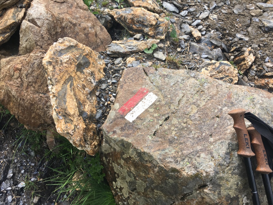
- Generally, very well marked trails
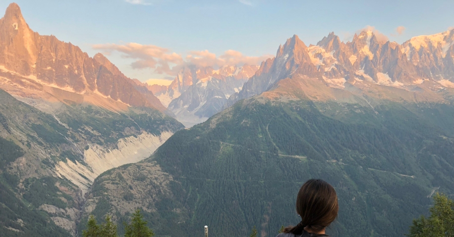
- The ”Monarch of the Alps” Mont Blanc is not one mountain, it’s a whole range
- Stunning Alpine scenery the majority of the way
- Visit three countries (France, Italy, Switzerland)
- Stay in refuges/hotels every night, no need to tent!
- Refuges and villages along the way allows for a light pack weight
- Tenting possible too, with restrictions
- Charming old world Alpine culture abounds
- Huge Glaciers, immense rock faces, wide Alpine meadows
- More waterfalls than you can shake a hiking stick at
- Acres of wildflowers
- Hike during the day; eat, drink and lounge in the evenings (not to mention lunch break)
- The city of Chamonix is one of the great hiking/outdoor meccas in the world
- We liked the Italian city of Courmayeur even better!
- Spectacular high variants for the hardy hikers
- Alternative low routes if bad weather or simple fatigue strikes
- Social experience of the Refuges full of cosmopolitan hikers
- Excellent transportation network
- Buses, trains, roads, even cable cars connect many points
- Many itineraries available
- Many re-supply options
- If things go wrong, in most areas you can bail out rather swiftly
- Highlights: the Col de Fours, Fenetre d’Arpette, Col de Balme, the days around Courmayeur and the last two days of the ‘Grand Balcon Sud.’
- No need to go with a tour group you can organize this yourself
- We have never seen ANY mountain like Mont Blanc…it’s hard to describe it unless you’ve seen it
- Refuges Elisabetta, Bertone, Elena, Bonati, La Flegere and Lac Blanc
- Optional side trips by cable car/funicular train up Mont Blanc itself
- Trip by gondola to Punta Helbronner or Aiguille de Midi well worth it
- Mostly good (though steep) trails, barring washouts
- Many great guidebooks; Kev Reynolds work is the definitive one
- Long hiking days during summer, ambient light until almost 10 pm
- Real chance of seeing Chamonix, Ibex
- Taking a rest day in Courmayeur is strongly recommended
But consider this before you hike:
- More than 100 miles of walking, and it’s not flat
- VERY steep trails in places
- Some rough sections; some lengthy, bad downhills
- Most will require 9-11 days to do the full circuit
- At least one rest day a smart idea
- A TON of up and down (ten thousand meters elevation gain; that’s more than Mount Everest)
- Many, probably most, who do this trek don’t walk the whole way
- Ten major ascents if high variants are included
- Even if you DON’T do the high variants you still need to assault many steep grades
- Long, very exposed sections with no easy retreat to shelter
- Snow may linger well into the summer in some high cols (we saw it in August)
- Late afternoon thunderstorms almost a daily ritual in the Alps
- Expect at least a few days washed out by rain, low clouds
- The speed with which bad weather moves in can be quite shocking in the Alps
- Ladders and other appliances bolted to mountains (actually not that many)
- The “Delicate Passage” near La Flegere (actually not that bad going UP)
- Rough, exposed section between the Cols Bonhomme/Croix du Bonhomme/Fours
- Roughest section on the main tour is the area around Brevent; but the Fenetre de Arpette variant probably the roughest overall
- Very tough (and scenically lousy) first ascent out of Les Houches is disconcerting
- The last day is by FAR the hardest
- Some of the gnarliest sections of trail were through wooded areas (roots plus rocks)
- This is NOT a wilderness hike; livestock, towns, cafes, roads, ski slopes, power lines…
- You will hear cowbells in your sleep for months
- Many areas carved up by ski industry development
- Crowds, especially around the areas accessible by ski lifts
- Many day use areas clogged with rude, loutish non-hikers
- Huts often overrun with people
- Some refuges are nice; others are cramped, airless dungeons
- The TMB can be expensive
- Switzerland is especially expensive
- You will be tempted to eat, drink and tourist yourself into destitution
- Quite a lot of road walking, especially on low variants
- The most confusing sections are those that cross through towns and ski areas
- Most agree the least well marked section is Italy and the best France
- Many of the Refuges near roads are actually more like cheap flop house motels
- Those who tent are not always welcome at or near the refuges
- Many of our fellow hikers tented; most told some tale of woe involving the experience
- While many refuges claim to offer hot showers, sometimes cold water is substituted. ?
- Lowlights: The first slog to the Col de Voza, the ski-lift infested areas around the col de Checrouit/Plan Praz, the Col de Forclaz and most of the middle part of Switzerland
- In fact, most of the Swiss segment of the TMB, while pleasant, is rather forgettable (the Fenetre d’Arpette notably excepted.)
- Europe is a surprisingly inconvenient place by American standards
- While re-supply and transport options abound, they inevitably are closed, not running or on vacation in the Maldives when you reach them
- The best airport to fly into by far is Geneva. It’s also one of the most expensive in Europe to fly into
- Transportation strikes in France and Italy are common and can impact your plans
- Beware the Col de Tricot and the Fenetre d’Arpette in bad weather; both can be bypassed
- Several brutish downhills – into Courmayeur (Day 4) Tres-la-Champ (Day 9) and the final one into Les Houches (the worst)
- Some confusing places where many trails go in different directions, especially at the Col de Balme and the area known as the “Tufs”
- GPS often comes in handy (but is not required)
- Carry a good contour map and guide book
- Cell phones work in many areas but power can be a problem
- Expect to see mobile devices jammed into every available power strip at all refuges
- Carry a good battery pack and European wall adapter
- A map that shows side trails is very handy, there are many in the area
- Note that the popular Reynolds Guide, while excellent, totally downplays does not fully convey the challenges of many sections (Kev must be a cyborg.)
- Most places English is spoken, but don’t count on it. French is very helpful
- We found the Italian people very helpful and pleasant
- We found the French people to be very….French. ?
- Most of the Refuges will let you upgrade to a smaller (or private) room for extra cost. It gets tempting…

General Notes and Observations on the Sections:
Section One: France to Italy
Section one is quite challenging, especially the first three days. Unless you are a very seasoned hiker in peak condition, our advice is not to be overly ambitious until you get a sense of how your body will handle the miles.
Very few descriptions of the TMB (and certainly not the Reynolds Guide) convey what a dusty, airless, viewless, joyless, backbreaking slog the first climb to the Col de Voza is. Many hikers bypass this by taking the funicular train out of St. Gervais les Bains, or by ski lift if one is running. It is easy to see why.

In Brian’s opinion, the route recommended by Reynolds on day one – over the Cols de Voza AND Tricot – is too much too soon for the average hiker. Sylvia and I bypassed the formidable Tricot and climbed a side trail to the Miages instead.
The low options on days one, two and three are rather uneventful (but still sometimes quite annoyingly steep) walks through woods and villages with a lot of it on dirt or paved roads. Stick to the higher ground as much as possible but always been mindful of weather and overexerting yourself.
Les Contamines was another of our favorite little towns.
We recommend the high option of the Col de Fours. Not only is it spectacular, but it cuts out some distance and some road walking and does so for not much extra elevation gain. We do however advise attempting it at the beginning of day three, not the end of day two as the Reynolds guide suggests.
Beware bad weather in the exposed mile between the cols Bonhomme/Croix Bonhomme. Very easy to lose the trail in this wilderness of rocks.
The Refugio Elisabetta has somewhat of a bad reputation with many, but we LOVED it. Overhung by stunning glaciers, a stay here is highly recommended; it was Sylvia’s favorite of the whole trip.

Generally speaking most hikers reach their stride by the end of section one, if they are going to reach it at all.
Courmayeur is the crux of the hike: if you can make it here, your odds of completing the entire hike are excellent.
If you get turned off the main trail on one of the many herd paths, don’t panic. Whatever path you are on is likely going to end up in the same place as the main route eventually.
Our opinion is that the much maligned downhill into Courmayeur at the end of day four, while certainly not fun, is not that bad if taken with care. There is no reason to bypass it using the gondola (and paying the fee.)
A rest stop in Courmayeur is advised and will not be wasted.
If you stay near the Monte Bianco Skyway in Entreves or La Palud, consider descending by the alternative route that Reynolds describes (the Courmayeur Refugio Monte Bianco Route.) These places are a good forty minute walk, uphill, out of the main town.

Section Two: Italy to Switzerland
The second section is notably easier than the first.
By now your body should start to become accustomed to the miles. If it isn’t, remember that much greater challenges lie ahead.
The ascent out of Courmayeur is another maligned climb; again, we did not think it so bad if, as Reynolds recommends, you simply take it slow.
Any and all of the rifugios on the Italian stretch (Elisabetta, Bertone, Elena, Bonati) were well situated with awesome views and we wouldn’t be unhappy staying in any, except maybe the Maison Vielle. Bonati was Brian’s fav of the tour.

The entire Italian segment, all things considered, was our favorite part of the whole Tour. ?
From Bertone to beyond the Swiss Frontier is one continuous parade of views
Mont Blanc massif is steeper and more dramatic on the Italian side, with HUGE cliff faces
Other than the climbs into/out of Courmayeur, no really difficult sections in Italy
The worst eatery of the whole tour was the La Peule just across the Grand Col Ferret; the entire staff looked and acted like they were serving out a prison sentence
We were generally unimpressed by the facilities on the Swiss leg of the TMB; Champex was the only really nice place we stayed in.

Trient, with its unmistakable Pink Church, is charming but far too small to take a rest day in. There is nothing there besides the Refuges.
Note that while day seven is the easiest day on the TMB, it is NOT flat; there are a couple sharp downhills and a good climb at the end into Champex.
Attempt the Fenetre d’Arpette if you can; it may be the best view on the hike. But be warned; it’s exposed and reputed to be the roughest climb BY FAR
The section that bypasses the Fenetre, the Alp Bovine, is not as easy as it sounds, and is itself somewhat exposed
The Col de Forclaz is a dismal road crossing with an overpriced restaurant/hotel. In good weather, it is an absolute madhouse overrun with day hikers.
If you are not going to do the Fenetre d’Arpette, there is a very good argument for skipping everything between La Fouly and Trient.

Section Three: Switzerland to France
Section three is by far the hardest of the tour. There are no low variants, only high and higher.
This is also the section most heavily served by cable cars; crowds and the temptation to bail out will be greatest here.

The much ballyhooed ‘Passage Delicate’ (The ladder/rung section between the Aiguilette D’Argentiere and the Tete Aux Vents) is typically encountered about mid-day on Day Ten.
The Passage is entirely non-technical and not very difficult if done in the anti-clockwise (uphill) direction.
The entire Passage basically consists of an upper and lower set of ladders, both brief, with some platforms, chains, and rungs in between, and the tallest of the ladders is perhaps 25 feet high. Twenty minutes at most is required to negotiate the hardest sections.
Any hiker who has gotten this far should be able to tackle the Passage without difficulty, unless they have a serious fear of ladders.

Much more problematic than the ladders are a re-appearance of the sketchy wooden steps bolted to the rock on this section, some of which are very steep.
The things to watch for on the ladders are rockfall, the transition from ladder to rock, and the presence of slower hikers queuing up ahead.
Note that there is a second short ladder section on the Lac Blanc alternative and one just below Brevent, which may be the trickiest of them all.
We feel ascending the ladder section to be far more prudent than descending and would recommend the trip in the anti-clockwise direction for this reason alone.
With that said, we did encounter many who passed this section in the clockwise direction and were quite alive.
All things considered we actually consider Day Ten, ladders and all, to be the LEAST strenuous day of the final section.
The unrelenting downhill from the Aiguillette des Posettes to Tres-La-Champ on Day Nine is the second worst descent of the entire tour barring the last one, in our opinion…lots of sketchy wooden step rungs and it is alarmingly exposed.
The Col de Balme is a very confusing place with trails going everywhere and signs pointing everywhere, which sometimes contradict. Exercise care in choosing trails.
Note that it is a LONG distance from the Col de Balme to tree line; consider an alternate route (there are many) if weather threatens to turn ugly
The diversion to Lac Blanc on Day Ten is scenically well worth the extra effort to hike it but be warned…this area is overrun with tourists who come up the cable cars. Expect the lakes to be MOBBED if you hit them in the afternoon.
The second lake at Lac Blanc behind the first is bigger, better and usually less crowded than the first.
Note that Lac Blanc refuge was closed in 2018; a pity because it does have the single best location in the whole tour, once the crowds depart.
From the Tete aux Vents to tree line above Les Houches…a good two days later…is one continuous panorama: The Grand Balcon Sud.

A sensible suggestion made by Kev Reynolds: in the event of bad weather on the last section, simply ride the cable car down to Chamonix and see if the weather looks better the next day.
A stop at the La Flegere refuge is another not to be missed.
Be prepared for a LONG walk on the last day. It is the hardest of the tour excepting perhaps the Fenetre d’Arpette section.
Day 11 is pretty straightforward until the big uphill beyond Plan Praz. From that point on, it doesn’t stop throwing things at you until you reach Les Houches.
We found the rugged, closed-in area between the Col du Brevent and Brevent proper to be the most difficult area of the entire hike. Ledges, scree piles, an oddly pitched ladder, a dicey snow field, difficult route finding in places…
The area around Brevent is NOT a good place to be caught in bad weather. Be wary because you will likely reach it in the afternoon when thunderstorms are most likely.
We came away with a poor opinion of Brevent, which has a fine view, but is really a shabby little snack bar and cable car station situated amongst a big pile of rocks.
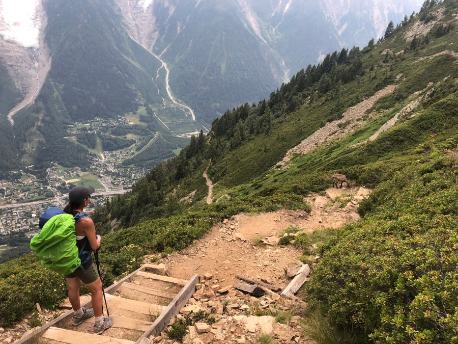
If you are going to see a Chamois or Ibex it will likely be somewhere around here (we did!)
Our advice is to give the skies a good, frank appraisal, then descend from Brevent to the more level ground visible below as rapidly as safety allows.
From Brevent it will take a strong hiker at least an hour to reach treeline…an average one, closer to two.
The final descent in Les Houches is the longest and hardest, by FAR, of the whole tour. None of the others even begins to compare.
There are a few dicey washed out sections on the final descent, a couple of which have chain or handrails assists. But for the most part it is straightforward.
It is the very long and continual nature of the descent, rather than its steepness or roughness, which makes it such a monster. The first hour or two doesn’t seem that bad. But by the third hour…
There are three places where one can escape the Grand Balcon Sud by cable car: La Flegere, Plan Praz, and Brevent. The ride is not free. Once you pass the last of these, the only way down is the walking route.
The Refuge Bellachat, about an hour or so out of Brevent, offers a sound rest stop and shelter in bad weather.
Note that the sketchiest sections of the descent come between the Bellachat and tree line.
Our experience was most people do not walk down the last leg to Les Houches…most bail out by cable car at Brevent.
The first place you could arrange for a pickup (or finagle a ride) is at the Merlet Zoo, maybe an eighty-to-ninety minute walk from Les Houches.
The total descent from Brevent to Les Houches train station took us an exhausting four hours. Brian was a complete mental and physical shambles at the end, forcing Sylvia to do the celebrating for him.
Here’s a day by day breakdown of our eleven Day tour:
Day 1 (Les Houches to Refuge la Truc) HARD
Day 2 (…to Refuge Bonhomme) VERY HARD
Day 3 (…to Rifugio Elisabetta) VERY HARD
Day 4 (…To Courmayeur) HARD
Day 5 (…to Rifugio Bonati) HARD
Day 6 (…to La Fouly) HARD
Day 7 (…to Champex) MODERATE
Day 8 (…to Trient) MODERATELY HARD
Day 9 (…to Tres-La_Champs) VERY HARD
Day 10 (…to La Flegere) VERY HARD
Day 11 (…Return to Les Houches) STRENUOUS
Basically, days 1,2,3,9,10 and 11 were the tough ones. The five in the middle are not that bad.
We also took two rest days…One (badly needed) at Courmayeur and a second (of debatable value) at Trient.
We took the high variants at the Col de Fours and Lac Blanc, and part of the high variant on Day One (we skipped the Col Tricot and ascended directly to the Miages.) We skipped the Mont Saxe and Fenetre d’Arpette entirely.
Brian and Sylvia covered ALL 100+ miles on foot. No cheating. We did this as a point of pride. Whether you decide to do this yourself is your decision; our advice is: hike your own hike.

Before you Go…
The Tour du Mont Blanc is a logistically complex undertaking no matter how you do it.
When we hiked in South America we used a guide service (and would do so again, they are cheap in South America.) In Europe, we felt there was no need to do so, and still feel this way. (Guide services there are very expensive, and in our opinion unnecessary.)
The first thing you should do is get yourself a guide book. We recommend (as does just about everyone) the definitive guide written by Kev Reynolds and published by Cicerone. It is clear, concise, easily understood and contains easy to comprehend maps.
We used Kev’s book exclusively. In retrospect we should have purchased a SECOND guide book; it is best to have two takes on something. We advise everyone do the same. You don’t have to bring both books with you, but you SHOULD bring at least one guide.
A map is not absolutely essential but comes in handy. There were a couple of times when Brian readily admits he could have used one. Note that maps are available all over Chamonix, Courmayeur and most of the major towns.
Brian ended up making do with this paper map that served as a place mat in many restaurants. It was, needless to say, not exactly an official contour map.

The second thing is to decide where you are going to fly into. There is no international airport in Chamonix. The closest and most convenient is Geneva, Switzerland. (Due to a quirk of geography, Geneva is actually NORTHWEST of Chamonix…the same general direction as Paris.)
Geneva is about an hour from Chamonix by car, slightly longer by train. Most who come here use Geneva as their entry port, and there are many transportation options to get you from Geneva to the Mont Blanc area.
Another option is Paris. Though MUCH further from Chamonix (six hours by car; about the same or a little less by high speed and local trains) Paris is very often much cheaper to fly into. The cost of a longer train ticket must be factored in; but still, if you are flying in from North America, Paris may be a more affordable option than Geneva.
Others we met flew in from the Italian cities of Turin (Torino) or Milan (Milano) and took a bus north; we have no details about this, but the distances are not small, as you can readily see from looking at a map.
We chose Paris as our entry point. Partly this was out of a desire to visit the City of Light and partly because there is a reasonably priced non-stop flight from RDU to Paris.
All we can say is, it worked. We got there. But we advise you check the flights into Geneva first…we would not advise the Paris option unless you are going to be touring that city as well.
(We can provide very exacting details about the Paris option upon request.)
The third thing is to decide how many days to spend and what your route will be. For ease of planning, we recommend the eleven-day option described by Kev Reynolds in the counter-clockwise direction. We also recommend taking one rest day, preferably at Courmayeur. But we met people doing all sorts of itineraries…eight days, six days, clockwise, counterclockwise, starting in Courmayeur, starting in La Fouly, starting in Trient…there are many, many options. Your start and end point, and the number of days you have available to hike, will determine the limits of your trip.
Note that the fastest most hikers can reasonably do the full circuit is eight days, and that is with short cuts. If you have less than nine days to work with, our recommendation is to do part(s) of the route.
If you have only a few days, the best sections scenically are those above Chamonix and either side of Courmayeur. Another advantage to these areas is cable car connections allow you to zip down to the valleys in a hurry.
If you have to leave out something, the least interesting sections are everything from Les Houches up to where the roads end in Les Contamines, and basically all of Switzerland.
Next, decide your plan of attack for accommodations. This will be the most complex part of the planning.
One of the best things about the hike – the fact you can sleep in a bed with a roof over your head, maybe take a shower, and get dinner and breakfast – is also one of the things that makes it such a severe logistical challenge. Namely…making all the reservations needed to have that bed, roof, shower and breakfast every day for many days at different locations.
At one time this was VERY difficult because there was no site where you could do all the bookings. This has improved somewhat…there is STILL no one site where you can do everything, but you can now do most things in one place.
Sylvia and I used the montourdumontblanc website to make MOST of our bookings. This seems to be the most popular way to do the tour right now.
http://www.montourdumontblanc.com/uk/index.aspx
(you can also reach this site at this link…one takes you to the other)
http://www.autourdumontblanc.com/en/
Of the eleven different accommodations we stayed at on the tour, MOST of them were bookable here. A few were not; I believe the Elisabetta, Bonati and Lac Blanc were the three that were not, and two of those we booked by emailing directly. One we had to call directly; Sylvia made the call and we can’t remember which one, but Brian thinks it was the Lac Blanc.
We booked our hotels in Chamonix and Courmayeur directly through Expedia.
We generally had a good experience with the Montour website. The site does charge SOME fee (which it is very coy about, doesn’t tell you anything till you are ready to book.) Or you could skip the fee by simply doing all the bookings in one place; it’s possible with email and Google Translate. But keeping track of it all is the sore spot.
Many guides and advice sites recommend not booking too far ahead, but rather hiking with an open itinerary and booking the night before you arrive, by calling ahead or having the refuge staff call ahead. The plus side of doing this is a very flexible itinerary that can easily be adjusted to the circumstances. The down side is that the tour is VERY popular now and these places will fill up. Especially the ‘choke point’ refuges in areas where there is no other place for miles. These are the Bonhomme, Elisabetta and Bonati (and if the Lac Blanc is closed, the La Flegere as well.)
Rick McCharles, whose website besthike.com we always recommend and use as a resource for international hikes, advises the ‘reserve as you go’ option. But…he prefers to tent. We opted NOT to tent for many reasons, the most important being a desire to keep pack weight down.
Sylvia and I chose to book everything ahead, accepting the risks of a rigid, point to point itinerary over the hassle of trying to book on the fly in a foreign country. Brian’s bungled attempts to learn Tarzan French contributed heavily to this decision; he wasn’t confident enough to be able to attempt a seat of the pants plan.

In the end it worked out exactly as advertised…BUT. It might well have ended much worse. Weeks before we hiked, the French rail workers announced a major strike on the same day we were scheduled to travel. As it turned out this did not impact our plans…but if it had, and we had arrived in Chamonix a day late, all of our bookings would have fallen like dominoes.
We would advise you consider your options carefully, but if you DO decide to leave your itinerary open, be aware that we did see many of the refuges fill up. The Elisabetta was turning people away out into the rain when we stayed there.
We would advise you book in at least the Bonhomme, Elisabetta and Bonati well in advance. In the more populous areas like Les Contamines, Courmayeur, La Fouly, Champex and Tres-La-Champ there is probably no absolute need to do so.
Check your passport and make sure that it is not expired prior to leaving. No visa is needed for a stay of less than 90 days in France, Italy or Switzerland, and there are no border crossings to worry about in the European Union. But make sure your paper work IS in order.
For those in the USA, The US State Department website has a lot of valuable information on travel rules, warning, notifications, etc.
The French Rail site is a also a good one for updates….
To book trains in France, we used the Trainline website. Very easy.
The best site on shuttle buses in the Chamonix area is the Chamonix.net, which has a lot of good travel links in general.


What do I need to Bring?
Our advice is to bring as little as possible. If tenting, you will obviously not have the luxury of lightening your tent weight by staying indoors…you will have to rely on your own hopefully lightweight gear.
If you are taking the standard hut to hut approach, bring a medium sized backpack (35-40 liters will suffice) a few warm layers, extra socks, rain gear, a hydration system and spare water bottle for carrying extra, a light weight sleeping sack or bag liner (if you don’t bring one you will be forced to buy a cheap on in the first refuge, it is required by law, costs about 5 euros) whatever toiletries you need, sunscreen, hat and gloves, camera and electronic gear, guidebook, maps, some cash and credit card, ID/passport, some basic uh-oh gear…and little else.
Most refuges are now accepting credit cards, IF their internet connection is up, but cash in many places is still highly recommended.
You do not need to carry more than a few snacks. Sylvia and I carried a few packets of Gu and some pieces of bread or crackers pilfered from the breakfast cart…there will be no shortage of re-supply points on most days. There is also no need to carry a boxed or bagged lunch…you can simply stop at a refuge or café on the way.
Note that while water is plentiful, if gathered from natural sources it will need to be boiled or filtered. Livestock is roaming everywhere.
Also note that most bigger hotels in Chamonix/Les Houches will hold your luggage until you get back from the trip. The smaller gites/refuges will not do this, and at last check there are NO storage lockers of any kind in the Chamonix train station.

How can I get Ready?
Fortunately, there is no real need to worry about altitude here. The highest point of the TMB is a little over eight thousand feet, so elevation is not going to be much of a factor.
What will be a factor are the miles. There’s a lot of them. And the up and down. And VERY steep trails. To get ready, walk as much as possible with weight on your back, and do as much walking as possible uphill AND downhill on the steepest trails you can find. Obviously, it helps to be able to train in the mountains, and these do NOT necessarily have to be high mountains. The TMB after all is NOT a high elevation mountaineering route, it is a walking tour of high alpine valleys that crosses some comparatively moderate (by Alpine standards) passes. The height of these passes is equivalent to a major Appalachian summit.
And that’s exactly how we prepared, by hiking in the Appalachians. In fact, we prepared by doing sections of the Appalachian Trail and surrounding trails. The summit of Standing Indian Mountain in North Carolina is actually higher than the Col de Voza, for example. So, don’t fret if you don’t have big mountains at hand, even hills will do.
But you must do a LOT of walking. Our advice is to build up slowly, or else you will encounter the devil’s paradox of athletic training…you must train to avoid injury and burnout, but the harder you train, the more likely you are to injure yourself or burn out. The risk of this can be reduced significantly if you begin within your limits and build up slowly.

If things go bad on the trail…
The TMB is NOT a wilderness hike. Parts of it do go into uninhabited wild areas, but the trail always leads back to an inhabited area eventually, and a very good transportation network allows relatively rapid escape. There are also many places along the way to seek help or go to ground.
We recommend that you carry a basic Uh-oh kit that any hiker should carry on any hike…it does not need to be elaborate. For a hut-to-hut hike, effectively you are doing eleven separate day hikes chained together. And that is how you should prepare…basic survival equipment. Pocket knife or multi-tool, fire starter, compass, map, space blanket, signaling device, etc.
If you are tenting, you will be responsible for your own wellbeing at all times. Your preparedness will need to be greater, and your survival bag of tricks deeper.
If you have unlimited time and resources, you can do the trail as you please, stopping and starting at any time. But very few have this luxury. Most hikers will have a finite number of days and a hard stop after which all hiking must cease…and reservations that may be hard or even impossible to re-book on the fly.
Our suggestion is to have a plan ready for EACH of the following contingencies:
- You are delayed in reaching your start point and forced to begin the hike later than expected (this NEARLY happened to us.)
- An injury or other situation forces you off the trail for a few days, and therefore you must skip ahead (or otherwise shorten the itinerary)
- An injury or other situation forces you off the trail, period
- You reach Courmayeur (or an equivalent checkpoint) but have serious doubts about your ability to continue
- One of the refuges cancels your reservations or becomes unavailable due to unforeseen circumstances (this DID happen to us.)
Our advice if possible is to set aside AT LEAST two weeks for the entire hike if you plan the full itinerary. Of course, this may not be possible for all people. But the more time you have, the better you will be able to deal with unforeseen things that arise.

Our final piece of advice would be to learn at least SOME conversational French. Brian’s attempts to learn it were lacking, and the experiences did suffer for it. We muddled through but…the experience would have been better had we been able to communicate fully. Sylvia on the other hand was able to speak passable Italian and this was a HUGE help in Courmayeur.
Is the Tour du Mont Blanc for YOU? Brian and Sylvia cannot ultimately tell you the answer. As stated, this is NOT like other hikes we have done. The distance and difficulty will likely prove too much for people who don’t have a passion for walking. Anyone in poor shape is likely to have a miserable time even if they get through it alive. Ask yourself these questions…Can I walk a day in the mountains? Can I then get up and do it again? And again? And Again? Do I mind doing it in the rain? In a full day of rain? In THREE DAYS of rain? What about in the heat? What about when you have had enough and feel like quitting?
The TMB is primarily a test of physical and mental stamina. There is nothing technical on this trip that would prevent any able bodied person from doing it, assuming they are mentally and physically prepared. But you must WANT to do this very badly. An unmotivated person is not likely to finish.
The payoff for this hardship? Look at the pictures we took. Day after day after splendid day of walking in an Alpine wonderland. What we wouldn’t give to go back for just a day! (But give me a bottle of Advil first.)
So the better question is, are you willing to endure the hardship to enjoy the many things this trip has to offer? If the answer is yes, Brian and Sylvia believe that most fit people with the willingness to do so can complete the TMB, as long as they don’t try to overreach, especially on the first few days. If that sounds like you, we can only recommend this life changing walk in the strongest possible terms. The TMB is perhaps the greatest experience of either of our lives…so far.
In fact…we are already dreaming of the Swiss Walkers Haute Route. Which many think is better. ?
