Fitz Roy: Day 3
**Completed in November 2019, Fitz Roy (Los Glaciares National Park of Argentina) is Sylvia and Brian’s sixth BucketList adventure completed together. It is also the furthest they have ever ventured for a hike.**
The day had finally come.This was the hike that we were looking forward to perhaps more than any other on this trip. This was the day we would go to visit Fitz Roy itself.

Laguna de los Tres…The Lake of the Three. This figured to be the most spectacular of the hikes we would do on our Patagonian trip…especially with our washout on the Towers of Paine. All we needed for this one was one thing…clear weather. And it seemed we had it. The day dawned partly cloudy, but with a strong sun that was visibly shredding the cloud cover.
But we also knew that this one might also be the toughest. It was a long day, maybe eight hours of hiking, and over the last kilometer before the lake, the trail rises a brutal 1400 feet. A couple we had met earlier in the trip had described it as tougher than anything on the W. And if we survived this, we faced a hike of nearly ten miles back to El Chaltèn.
If we wanted this great mountain in our Bucket, it was not going to walk itself in there. We would have to earn it.
Brian had already determined that the best way to tackle Fitz Roy was to approach from the north, from the trail head at the El Pilar Hostel. Most — including the large tour groups — do it this way, as it saves some miles, removes a significant uphill, adds an extra viewpoint (Piedras Blancas) and generally puts the prevailing wind at your back most of the route. On the return leg, we would simply walk back into town along the regular trail route.
We had arranged a shared shuttle to take us to the trail head at 8 am. So it was that we were up and waiting in the cold for this ride outside our hostel. We sat and talked to another hiker, also bound for Laguna del los Tres, who was waiting for his own private taxi; this man would be headed next to Chile and Torres del Paine, so we shared some of our experiences with him. Our rides showed up at the exact same time, but as he took the direct route, he likely arrived at the trail head before us. We wished each other luck, and did not meet again; we assume he accomplished his hike.
The ride from town to the El Pilar lodge takes about a half hour. Our shuttle, which was operated by a reputable provider, proceeded at a reasonable pace up the road which parallels the Rio de las Vueltas. We saw many vans, cars and even large buses careening down this bumpy gravel road, and those groups certainly did reach the trail a few minutes earlier than we did, but what shape they arrived in is anybody’s guess.

At the El Pilar (where, we should warn you, there is no public restroom, as signs vehemently warn) the trail begins amidst a grove of megellanic pines, rising steadily at a gentle pace through light woods with sporadic views off to the right. There is nothing even remotely steep or rough about this part of the trail.


Soon it reaches the Piedras Blancas viewpoint (people who want to hike here for this view alone should be warned — the view, while impressive, is actually a partial one through trees, and is of questionable merit by itself.)


This trail itself, contrary to what we had been told, was in excellent shape. There were few boggy or flooded sections, and signs of good trail work and erosion control abounded. In fact we passed a trail crew hard at work on one section, swinging away with axes. The Argentinian National Park Service has a reputation for being more helpful and organized than their Chilean counterparts (CONAF) and it certainly showed.
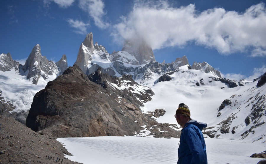
After Piedras Blancas the trail winds through woods and brush to an open meadow, and here one is presented with the first view of Fitz Roy itself, poking its rocky spires above an adjacent ridge. Of course, by now you’re used to seeing this giant presence from back in El Chaltèn. But you are about to get much closer.

After the first meadow the mountaineering camp of Rio Blanco appears, and here is another even better view. From here one can plainly see the challenges that lay just ahead, as the trail can be observed rising sharply along its famed last kilometer to the bench of land where the lake, and its storied view, lies beneath the shadow of Fitz Roy.


After leaving this view the trail heads back into the trees, reaches a junction with the trail coming in from El Chaltèn (which would become our path on the way out) and then hits Camp Poincenot, the hikers campsite. Here we stopped for a snack, and a bathroom break; there are few other places to stop after this that offer any privacy.
Soon after crossing the stream on a narrow bridge (where there was a man singing to the mountain gods, accompanying himself on the ukulele) the trail steepens sharply and begins its final push to the lake. As advertised, this section is very steep, quite rocky, and entirely exposed, and it all gets more so as one nears the top.


Despite this, we did not feel the trail was anywhere near the worst we have ever seen. Most hikers of reasonable fitness should have no trouble with the ascent as long as they pace themselves and add/remove layers as needed. Sylvia was once again the faster hiker up this stretch, but neither of us had any undo issues with the steepest bit of this trail.

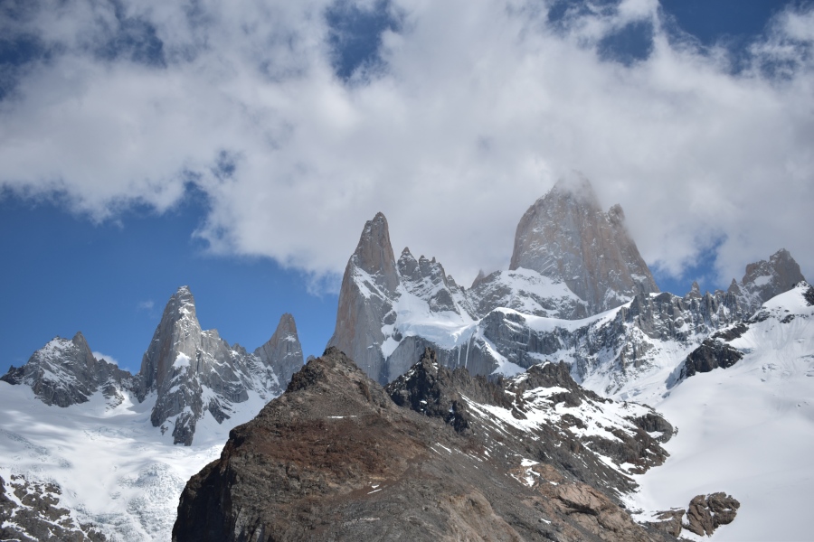
Near the top one crosses what is probably the steepest bit OF the steepest bit, this being a short (maybe 50 yards) but very tricky section of loose pebbley scree so steep that one could easy slip and fall even on the uphill. But once past this short section, there is nothing left to stand between the hiker and one of the great mountain views on Planet Earth…The Laguna del los Tres, The Lake of the Three.
And what a view it is.


Fitz Roy, adorned today with only a few shards of sparse cloud, rises majestically over the still frozen lake (though the ice was breaking up.) Attendant peaks studded with saw toothed tops rise amidst copious glaciers on either side. To sit there at the feet of this huge granite monolith is like sitting in the throne hall of a great king. And the monarch of this mountain court, complete crown of clouds, is undoubtedly Cerro Fitz Roy.
We were not the only admirers by a long shot. Throngs of people lined the rocks above the lake, sitting only almost every flat surface that could hold a human backside. More milled around by the lake shore itself, and yet more could be seen moving like a line of ants over the adjacent hillsides in search of better views for the obligatory selfie. It was mountain madness.


All those people could not fail to detract from the experience a bit — the crowds made it nearly impossible for Brian to GoPro — but how could we complain? We were here in the court of the Mountain King with superb weather for viewing. We had finally hit a home run on this trip. It was time to sit and enjoy the moment…and so we found ourselves a seat with a view of…what else: Fitz Roy.


Brian kept looking at the huge snowfield straight ahead of us, behind the lake, and waiting for the sun to trigger a massive avalanche. There were signs major snow slides had happened just recently, and on the way in we had heard several big avalanches crashing down near Piedras Blancas. But none disturbed the snow around Fitz Roy when we were there. Maybe the snow was simply held in place by shear spectacle, mesmerized by the moment.


Brian debated fighting through the crowds to take the short walk over to the Mirador Laguna Sucia, with its fine view of another lake that lies deep in a mountainous cistern. He would have liked to at least GoPro from up there. But we could see that the viewpoint was at least as overrun with people as the one we were sitting in was…Brian decided he had little desire to fight through the crowds just to end up in a spot yet more crowded.


We sat bathed in mountain views for more than an hour, simply reveling in Fitz Roy’s glory. The, all too soon, it was time to go. We had a steep descent ahead of us, followed by a very long walk back to town, which itself had a longish descent near the end.
Years of planning had led us to this spot, and now, the moment was almost gone. Such moments bring a strange mix of accomplishment and loss. No one and nothing, not even time, could take this moment away from us. And yet the adventure was over; already, it was slipping over into memory. Perhaps we will see Fitz Roy again, and in fact we would like to come back here. But it is also very likely that we will never stand upon the rocks of Laguna del los Tres a second time. There is simply too much else that has to be done, and too little time to do it in.
We had this same sensation all through the Tour du Mont Blanc…though by the end of it Brian was feeling too much pain and exhaustion to feel anything other than relief that it was over. All through the hike he kept saying to himself…”I had better pay attention. I am probably never going to stand in this spot again.”
But memories are what we took with us as we said our good bye’s to Fitz Roy and turned our backs to it, and our faces to the trail ahead. (Sylvia literally said to the mountain, “Good Bye, Fitzy!” There was of course no response from the mountain. There never is.)
The descent was long, laborious, and difficult…as expected. The first part, the loose scree, was toughest, and from there on down got progressively less and less bad as one got closer to the bottom. Sylvia, moving on a slightly better pair of knees, once again proved that when she is carrying a light pack, she is the faster hiker by far, reaching the bottom well before Brian (a fact that was rubbed in no less than twenty times later at dinner.)

The biggest problem Brian noted was not the steepness of the trail itself, nor the exposure…he had seen trails about as bad, maybe worse, in the White Mountains of New Hampshire and Maine. Anyone who has tackled the Tuckerman’s Ravine Trail, the Lion’s Head, or Mount Katahdin and lived will be unlikely to have any issues with this trail.
The biggest problem rather was the shear numbers of people — and the very large groups of people — who kept passing in both directions, making forward progress through many difficult sections a very tedious affair.
Brian, a fairly slow hiker on the downhills, would pause to let a faster hiker go past…then would come another, followed by another two, and then another; and by the time this last person passed, a queue of at least five people had formed below; and Brian, who also doesn’t like to be rushed, would wave them forward. And the cycle would repeat itself two or three times.
Suffice it to say it was a while before Brian reached the bottom, but he arrived no worse for wear. He did take an awkward sort of half-fall at one point (Sylvia had two hikers fall in front of her) but managed not to twist, bruise or break anything. Which, by the way, is his definition of a successful descent.
At the bottom as we rested, a sense of completeness was already dawning on us. The hardest bit of the hike was behind us. All we had to do now was walk back into town.
We were expecting this to be level and easy at first, followed by a descent that was described as moderate…but again we had ‘heard tell’ of moderate trails before that ended up being fairly strenuous in fact. And we’d be doing it on very tired legs. We hoped for the best, we we were in truth expecting one or two more steep sections, at least rivaling what we had seen on the Laguna Torre hike.
In fact there were no difficult sections at all, not even short ones. The first part of the hike is a flat walk, with many views back at Fitz Roy, assuming you have not had your fill by now. The middle section — which includes a Mirador of the Valley of the Rio de las Vueltas and Fitz Roy, and also an optional detour to Lago Capri (which we did not take) — is mostly wooded and rolling.


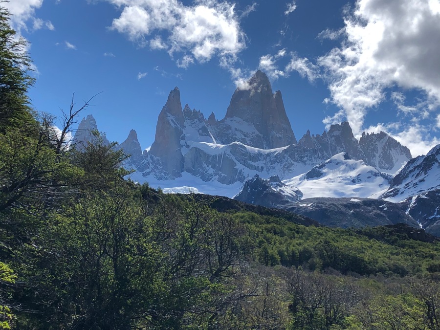
The final section, which descends fairly gently down to the floor of the valley, is the best one of the return leg, scenically…there are several fine open areas with fine views up the valley that reminded Brian of the meadows of the Alps. The late afternoon light was perfect, and we could have just stayed here forever…if we had not been so hungry.


The trail reaches town after a brief moderately steep section with a few high step downs, but far, FAR less demanding than what Brian in his worst nightmares had imagined. In fact, he was pleased and surprised. We had been prepared for a VERY tough day on the trail, and while Laguna del los Tres had certainly proved itself to be a demanding and difficult one, we had no problems with the trail at all.
In fact, the worst part of this hike in our opinion was the wretched slog through town to our hostel, which lay on the other side of El Chalten.
But now it was time to pause and celebrate…We had done the W, and now we had Laguna de los Tres! We had just done what many considered to be two of the best hikes in the entire world!


And in doing so, we had completed the main act of our Patagonian expedition. Our 2019 hiking season was over…we had crossed not one but TWO major bucket list items off the list. Now, it was time to go home.
But first…let’s eat! Time for a well earned celebratory dinner!

Did You Know? The Word “Chaltén” is native Patagonian for “Smoking Mountain” and this is the actual name of Cerro Fitz Roy. Many do insist upon calling it that out of respect to the indigenous culture. However, there are several mountain the locals called Chaltén, so it could get confusing.
…AND Did You Know? It’s called Lake of the Three because it is flanked by the three major peaks of this region…Fitz Roy, Poincenot and Cerro Torre. But the last is not visible from the Lake.

Next Up: The Long Way Home To The Other Fitz Roy