TMB Day 9: Trient to Tre-le-Champ
*The Tour du Mont Blanc is the most famous and celebrated hike in Alpine Europe and is the fifth Bucket List Hike that Brian and Sylvia have completed together. It is also our first hike together of any kind in Europe.*
After an uneventful rest day in Trient, which both Sylvia and I felt in retrospect was not really needed, it was back on the trail again for the final section of the Tour du Mont Blanc. By all accounts, this would be the hardest section. Ahead of us lay the much ballyhooed ‘Passage Délicat’, a ladder-assisted climb of the Aiguilles Rouges, considered by many to be the single most challenging part of the TMB.
But there would be no ladders today, just hard miles both up and down. We would ascend out of Trient to the Col de Balme, then descend to a sag before finishing up the final ascent of the day, to the ridge of the Aiguille des Posettes, followed by a long last downhill into Tres La Champ and our nights stay. It would be the second to last night spent on this trail.
We had been warned about this section by a hiker from California back in the Refugio Elisabetta on Day 3. She had considered it very mentally and physically draining. Although there is only one major pass to cross, there is substantial elevation loss/gain between the Col de Balme and the Aiguille des Posettes. And the usually laconic Kev Reynolds describes the final downhill as “Steep” and liable to “aggravate tired legs.” In the language of Mr. Reynolds, this is akin to a sharp warning.
(The previous day we had said good bye to the Swiss couple who were doing the Alpine Pass Trail…their route and ours diverged and we wished them luck. But during our rest day we did meet yet another young Swiss couple doing the Walker’s Haute Route…the Swiss are amazing! They LOVE mountains.)

The climb out of Trient is not bad by TMB standards. Routine slogging carried us clear of the trees and quite soon we were looking straight up a wide glacial slot between mountainsides at the col. The col itself is marked by the unmistakable Refuge du Col de Balme, visible for a good hour of the approach and growing larger only with a steady, disappointing slowness.
For most of this way we could also look back down on Trient with its pink church still quite visible, and the Col de Forclaz skulking above it.


As we approached the high point, what should appear quite suddenly over the lip of the pass but…Our Buddy, Mont Blanc! It was the first time we had seen the summit in three days.

Also in evidence at the Col, thanks to a preponderance of ski lifts threading every which way, are large crowds of people.


From here we also saw, for the very first time on the trip, the entire city of Chamonix laid out in the valley below us. Further down there somewhere was Les Houches, the beginning and end of this hike. The finish line was already in sight! But we were still a long way from it. Two more days of hiking, to be precise.


The Refuge de Col du Balme turned out to be very primitive; it has only a crude outdoor bathroom and offers no refreshments. Many people, no small number of them non-hikers, milled about taking selfies and enjoying the view, which was a grand one. The entire Mont Blanc Massif was on display from one end to the other!


Also on display were the twin spires of the Aiguilles Rouge, where tomorrow we would brave the Passage Délicat.


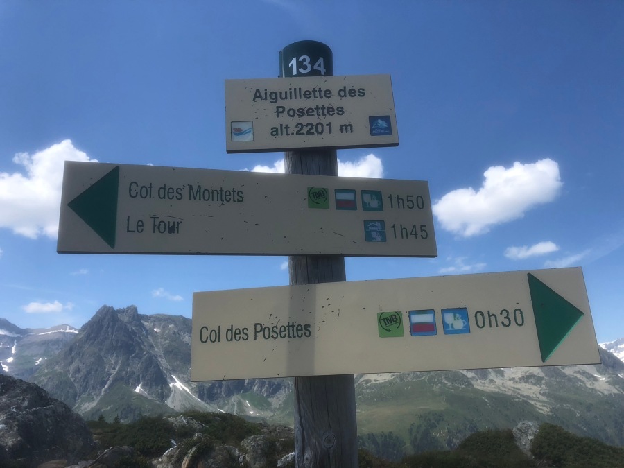
We milled for as long as we could stand to, munching on snack bars, before deciding it was time to leave. Almost immediately, confusion set in. There are dozens of trails leading away from the Col…not all are signed, and the signed ones are vague. We found two TMB markers that pointed in completely opposing directions, and just past one of them was yet another junction with no indications which fork was the correct one.


We found the Col de Balme the single most confusing place on the entire Tour. Rick McCharles of the adventure blog BestHike.com describes the TMB as often having “…several different paths, all leading in the same direction.” Though this was true in many places, it might well have been here, specifically, that he had in mind. He might have added that while the varying routes may well converge later on, not all routes are of equal difficulty nor scenic quality.


Following the lead of the same Irish couple we had been playing leapfrog with for a couple days, we set off toward what we thought was the highest and most scenic route. We were sort of right. The chosen route did lead us the right way but at entirely the wrong elevation. The path stayed just below the main ridge (where we were supposed to be.) Thus, when we finally arrived at an intersection which we surmised to be the high point of the days hike, we turned our heads to see – much to our dismay – hikers descending from an even higher point than we.

Among the descending hikers was the Irish couple, who told us that the main TMB had come up the back side of the ridge and we had apparently followed a cow-path variant. But, they assured us, the summit of the Aiguille de Possettes was right about us, barely a quarter kilometer off. It would be no great thing to backtrack to it, since the view was worthy. And this is exactly what we did.
(On the way up we passed a couple with a pair of screaming toddlers, one howling youngster apiece slung over the shoulder of each parent. Probably not the best moment to have a toddler meltdown.)


The view from here from this knife-edge ridge was three-hundred-sixty degrees of awesome…not only incredible vistas of the Mont Blanc range, but also views into new territory to the north, including Lac Emossen in Switzerland and its conspicuous hydroelectric dam. The weather on this, the ninth day of hiking, was among the best of the trip so far, rivaled or surpassed only by days five and six. It seemed that we could see forever.


But there were a few possible thunderclouds hanging on the horizon, and we had a long way to descend, and so we tore ourselves from the scenery and down we went.


Quickly it developed into the hardest downhill of the trip thus far. The path follows a worrisome section of exposed ridge…grand views to be sure, but completely unprotected from any storm that should appear; and on most summer afternoons a storm could in fact be counted on to appear. The M.E.P. kept looking around nervously, listening for the first clap of thunder, and wondering…where was the tree line? How much further?

Much further, was the answer.

Sylvia’s knees began to physically wear out in this section, which had the highest step-downs of the whole trip, and many, many wooden steps bolted into the rock, some of which were rotten or unstable. She was reduced in some cases to scuttling down the stairs sideways like a crab.

The trail did eventually reach the trees, which eased the M.E.P.’s concerns about storms. But the downhill did not slacken one bit until we finally reached the road…a more tired, footsore, and grumpy pair of people one is unlikely to meet. As we trudged along the final yards towards our hostel we knew that day nine had come as close to any since day 2 to beating us. And we also knew that ahead of us lay two more days that figured to be even harder.

A treat waited for us. The previous evening Sylvia had begged me to allow her to email ahead to the Refuge La Boerne and tell them to reserve a private room which had been previously offered to us, but which we had chosen at the time not to accept. We’d had enough of stuffy dorms by this point and I gave her the green light to book it assuming the room was still available. She’d sent the request but received no response, email being flaky in the mountains.
Well, on arrival at the very rustic (and somewhat cramped) refuge we learned that, yes, they had gotten the message. We had our own private room with private bath in the annex across the way!
Even though this was not my favorite room of the trip – the location in the annex was less charming than the historic main building – this WAS the only room outside the Funivia, in Courmayeur, where we enjoyed our own bathroom. Sylvia could not have been more thrilled.
Lunch was served outside that evening for the only time on the whole tour. We shared the table with yet another Swiss couple (“We’re from Switzerland – NOT Sweden!” the man proclaimed proudly) and a young girl from Norway – yet another doing the trail solo — who told us her adventures in the Lofoten Islands above the arctic circle. This may be a future Bucket List item of ours.
We rested well that night, for the end of our journey had been sighted. But in the back of our minds we were thinking not of the last day but of the one before it. No day on this trip did we look upon with as much trepidation as day ten. This would be the truest test of our mettle yet…the steep, ladder assisted ascent of the Passage Délicat. We had proven almost everything else by now, but we still had to prove we could do this.

Next Up: The Delicate Passage