TMB Day Six: Rifugio Bonati to La Fouly
We had a fairly restful night at the Bonati. Though it was a shared room, three of the seven beds were entirely empty, and one gentleman sleeping by the window, reading a book most of the time, said not a word the whole time. (Well he said six, actually…”Mind if I open the window?”)
The window guy departed shortly after first light, leaving the window bunk free expedition photographer Sylvia to lean out and take the following shots of Mont Blanc and the Grand Jorasses in the dawn’s early light. Every one of these shots is hers, taken under serious duress (her husband shouting at her, “Don’t lean out too far!”)


The breakfast at the busy Bonati was one of the best of the trip.

Then, it was back on the trail! Today, we would be crossing the Grand Col Ferret, our sixth major mountain pass of this trip, not considered to be one of the harder ones but not a cakewalk either. From there we would cross into Switzerland…Though sad to be leaving Italy, we were looking forward to seeing a new nation.
The Grand Col Ferret would also mark, for the time being, a diminishment in the quantity and quality of high mountain scenery. For a couple of days, the TMB main variant would snake through bucolic Swiss valleys and small hamlets that would hold the great peaks at a distant remove (though some of the high variants were bolder.)

After two days in the Swiss Vales we would spend our final rest day in the village of Trient. Both of us were in good spirits and good health, except maybe for our Crankles. Hopefully, two days of relatively modest hiking, followed by rest, would have us in an ideal spot for the final three days of the trip, which we knew were going to be very hard indeed.

But first we had to get there…and meant crossing the Col Grand Ferret.
The first part of this section is not difficult, as it contours across high pasture lands above the floor of the Val Ferret. To left are the monstrous feet of the Mont Blanc Massif; the Grand Jorasse falls behind, to the replaced by views of Mont Dolent and its attendant glaciers.

The trail eventually reaches the valley floor, road walks a bit, then heads back on a standard trail for the sharp ascent to the col. Just before the sharpest leg of the climb, it comes to the door of the Rifugio Elena.

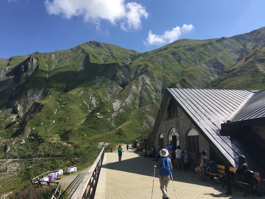
We neither ate not slept in this place; but we did enjoy a couple of sodas while setting on the immense concrete patio that overlooks the Pre de Bar Glacier. The Rifugio is partly built into the hillside like a bunker as a protection again avalanche. Kev Reynolds does not much comment on the view from it in his guidebook, other than to call the Pre de Bar a ‘drab’ glacier. We disagreed…Sylvia and I found this glimpse into a wild mountain ravine one of the finer and more intriguing views of the trip.


In fact, the Elena in Brian’s opinion had one of the best locations of any Refuge of the tour. We sure would have liked to have spent more time here.


One of the more amusing and interesting encounters of the trip happened here. As we sipped our Cokes, a man and his teenage son sat down beside us, and the following exchange (or something very much like it) occurred…
FATHER (With British accent): Son, have you seen the map?
SON (after a pause): No, dad, last I saw it was on the table at breakfast.
FATHER: Oh drat. It appears we’ve lost the bloody map.
SON: Oh, dear. What shall we do?
FATHER: Well…don’t worry son, we’ll muddle through somehow.
Here the M.E.P. decided that an intervention was necessary…we did in fact have a spare map….of a sort. At many stops on the TMB the restaurants/hostels will serve a meal with a place mat that is basically a crude map of the TMB. This one…

We had snatched away this one not to be used as a map but rather as a keepsake. Brian told the Englishman, well, I have a map…but NOT exactly a to-scale contour map.
The man quickly looked the map over, pronounced it to be the very thing and thanked use profoundly…it would do until they could purchase a new one. We had saved the expedition! Or so the M.E.P. would later claim.
At any rate, we talked to the English pair for a while…turned out they were from Birmingham and we doing an abbreviated version of the tour. Today, they would be headed to the same place we were (La Fouly) but from there would be taking a bus on to Champex, avoiding one entire section. We sat a while beside the glacier, talking of Trump and travel and other things until at last they moved off, new paper map in hand. We saw them again at La Fouly so the map got them at least that far…beyond that we have no idea what became of them, and so we wish them luck.
(The keepsake was easily replaced, by the way…every other hostel on the trip served on the same map. I believe I borrowed the present one from the La Flagere.)
(Also of note…Sylvia later cursed herself for failing to “ask how they felt about Prince Harry marrying Meghan Markel.” Alas, we were never to discover this either, it remains one of the great missed opportunities of the trip.)

Onward and upward we went. The Elena fell steadily below and behind, reminding us how quickly the past shrinks and disappears once you leave it behind. The trail steepened, turned to the right and a big cairn appeared, which alternately vanished and re-appeared several times behind contours in the land. Finally, we reached it…the Col Grand Ferret, the crossing point into Switzerland.


It was a somewhat crowded place.

From here you can look back over the entire route of the TMB in Italy…all the way to the Col de la Seigne (which by the way is the only other place where you can do this.) Close at hand are the glaciers adorning Mont Dolent and the Aguille de Triolet; behind (and soon to be lost from view) is the Grand Jorass, and the dome of Mont Blanc itself. Once over the Grand Col Ferret, Our Buddy would not reappear until the Col du Balme…another three days of hiking further down the line.


Also on display here are peaks which any student of the Alps will recognize…the Grand Combin, one of the ten largest in the Alps, looms near at hand. Further away is Monte Rosa (The second highest peak in the Alps, after Mont Blanc) and Grand Paradiso (the highest peak located entirely in Italy.) A very helpful (if hard to read) plaque on the summit pointed directions to each of the peaks. Alas, these interloping giants would again deny me my longed for glimpse of the Matterhorn.

After indulging in the sights for a while we began the journey down into Switzerland, our third country of the tour. We were entering the part of Switzerland that speaks mainly French (as opposed to the western half of the country that speaks mostly German) so the language situation would at least get no worse here. Brian’s ‘Tarzan Francais’ probably would not offend the Swiss to any greater degree than it had already offended the French themselves.

The views are fine the first few miles out of the Col but diminish rapidly as the high valley walls close inexorably in. By the time we turned down into the Swiss Val Ferret (separate and distinct from the Italian Val Ferret) we were getting only occasional glimpses of the higher peaks through gaps in the surrounding valley walls, as if from windows high up on a wall. “…The intimacy of the big mountains will be lost,” writes Kev Reynolds. He is correct. While we had many fine views over the next few days, the Swiss sections of the tour carried us furthest away from Our Buddy, Mont Blanc, and the optical wow factor suffered accordingly.


We eventually arrived at the Alpage de la Peule, a converted dairy farm that now serves as a hostel and restaurant (and from the looks of it, still serves as a cow barn as well.) Here, an irritable and indifferent staff served us milkshakes of unremarkable quality. (This might be overly kind; Sylvia described hers as ‘too sweet, yet bitter’ and ‘undrinkable’.)
While pondering the deficiencies of his shake, Brian noted the same GPS-guided Chinese hiker we had met on Day 3 while temporarily ‘misplaced’ in the Tufs. This young man, recognizable by his bright orange shirt and wide brimmed sun hat, was clearly walking back and forth in a befuddled way, as if he had misplaced himself yet again.

This was the second time we’d encountered the man today. About half an hour earlier, we’d passed him just below the Col Grand Ferret, tramping about as if looking for something (the trail there was unmistakable.)
After some wandering about, he eventually he walked away back toward where he had come and disappeared. The M.E.P., watching this transpire, dismissed the man’s behavior as either some acute form of mountain madness, or an over-reliance on a malfunctioning GPS. We banished the man from our minds entirely.
The M.E.P. would have done better to check his own maps. Only later did it dawn on us that the man might in fact have been on to something. Back at the Col, what I casually assumed to be confused stumbling about was probably for a search for an unmarked trail described by Reynolds as leading a ‘wonderful viewpoint’ from which the entire Swiss Val Ferret can be seen. And later, while we sipped our forgettable milkshakes at the La Peule, our man was no doubt searching for the “…higher and more scenic…” route described by Reynolds, which recently became the main route of the TMB.
We never saw this route; we must have walked right by it, despite the fact that we were looking for it. Doubtless it brances from the main trail BEFORE the La Peule and not, as we believed, after. Our Chinese friend must have consulted his GPS, realized this after the fact, backtracked and regained the trail. We would have liked to have asked him if that explanation was in fact the case but, as too often happened on this tour, this would be our last glimpse of him. He walked out of our story, and what became of him, his orange shirt and GPS, we would never know.
At any rate, we finished our underwhelming milkshakes, walked out the back of the La Peuly, and onto the road that would carry us down to La Fouly…oblivious to the fact that this was the LESS scenic low variant. But it was only when we were halfway down that Brian realized it to be the case. He kept looking for the junction of the scenic variant to appear…but it never did. Eventually he resigned himself to the fact that we had missed the opportunity and were now irredeemably consigned to the low route.
Here, once again, the M.E.P. stepped to the fore, proving himself to be a genius of navigation worthy of Scott, Magellan, Cook and other explorer who discovered ‘opportunity for posthumous glory.’ In his defense he can only offer that, like Shackleton, he brought all his crew back alive and well.
(As an aside, I would say 80% of the people walking made the same mistake. The low route out of La Peule was full of befuddled walkers.)

Eventually we hit the road below, began a walk along it, then diverged down a somewhat steep trail toward a river. The trail crossed the river and into a forest, where it ceased to be memorable in any way until it regained the road in La Fouly. This quiet, handsome but unremarkable hamlet of chalets is set in a wooden valley with some decent views, and right in the middle of it, we found our nights accommodation, the Auberge des Glaciers, occupying a prime location downtown.

My mother once said that if you can’t say anything nice about a person, don’t say anything at all. Well, assuming this rule applies to places as well, then I’ve already said too much about the Auberge des Glaciers. Here we would spend the least pleasant, most forgettable night of the tour by far.
In its defense, the Auberge did have a very kind of helpful staff, and the excellent market directly beneath it right off the street was convenient. Nothing else about it was. Suffice it to say, if you want a room in which to hang and cure meat, stay here. If you want to get a good night’s rest, stay elsewhere. Enough said.

But whatever the difficulties and disappointments, day six was in the books. We had arrived safe and sound in Switzerland, had quietly passed the halfway point of this trip (by my reckoning, the Col Grand Ferret) and for the third straight day, the physical difficulty of the tour had been on the wane, while our own stamina seemed to be improving. More hard hiking was to come, but the next three days promised to be the least challenging of the tour…with one being a full day of rest.
We had reached the land of Swiss Cheese and no holes had appeared in our plan. There had been no easy miles…but then, there had not been a single mile which had gotten the best of us yet.

NEXT: No Foolin’ (And no quittin’ either)